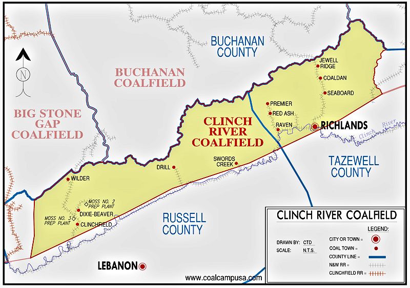
CLINCH RIVER FIELD
A March 21, 1990 article in the Bluefield Daily Telegraph titled "Heating Change
Sought for School" stated, "Rev. Richard Stone, a Jewell Ridge pastor, is leading a movement to convert the heating system at the elementary school
there from electricity to the town’s abundant coal. He feels the change would save money and help stave off the threatened closing of the
school."
Clinchfield Coal Company was a subsidiary of Pittston, and this is their Moss No. 3 prep plant as it looked in
1989, the year the facility was plagued by a conflict between the UMWA and the company. Moss No. 3 prep plant was built in 1957-58.
Knox Creek Coal Company's prep plant and Tiller No. 1 mine is one of the last mining operations in this coalfield. It was owned and operated by
Massey Energy at the time of this photo. In the 2020s, it is owned by Ramaco.
A 1924 Bluefield Daily Telegraph article stated, "Two hundred and fifty men will be
thrown out of employment this week
when the big coal operations of the
Consolidation Coal Co. at Seaboard
and Coaldan are permanently closed.
The shut-down is said to be the
result of adverse business conditions
and the low price of coal. Most of
the mines at Coaldan have already
been closed and the last car of coal
will be shipped from the Seaboard
mines by Thursday. The large commissary at Seaboard has already been
closed and the stock shipped to the
other mining operations of the Consolidation Coal Co. The store at
Coaldan will remain open according
to an anannouncement made Friday.
The entrances to the mines are being
sealed and much of the machinery is
being shipped away ..."
READING MATERIAL: "Wilder Days: Coal Town Life on Dumps Creek" by Kathy Shearer


May 2006 image by author
Coal camp built by Jewell Ridge Coal Corp. at Jewell Ridge, VA.

May 2006 image by author
The Jewell Ridge Coal Corp. office and store were combined in this building, which is still
in existence in the town.

May 2006 image by author
The layout of Jewell Ridge is interesting in that the company housing is high on the ridge and the
coal mining complex that is no longer extant was down in the hollow.

Aug. 1946 image from "A Medical Survey of the Bituminous Coal Industry" via the National Archives
Jewell Ridge in its prime.

Image from the book "Mineral Resources of Virginia" published in 1907, via Google Books
An ancient photo of the coal mine and part of the coal camp at Seaboard, Va. It was opened in 1904-05 by Seaboard
Coal Company. By the 1910s, Empire Coal Land Corporation was the operator of Seaboard. Carter Coal Company, who owned the mines at Coalwood and
Caretta, W.Va., ran Seaboard after Empire.

May 2006 image by author
The few remaining company homes in Seaboard, Va. show how the company alternated house
styles to break up the monotonous appearance that usually characterized housing in coal camps.

Map showing Seaboard coal camp and surrounding mines (No. 6, 6 1/2, 7, 8, & 9).

May 2006 image by author
This latter day loadout on the edge of Seaboard appeared to be no longer in use.

Nov. 2006 image by author
Ruins of the Raven Red Ash Coal Company tipple in Red Ash, VA.

Aug. 1946 image from "A Medical Survey of the Bituminous Coal Industry" via the National Archives
Old photo of miners walking home past the Red Ash No. 2 tipple.

Aug. 1946 image from "A Medical Survey of the Bituminous Coal Industry" via the National Archives
Vintage view of Raven Red Ash coal camp shows how some coal camps
really didn't have maintained streets.

Aug. 1946 image from "A Medical Survey of the Bituminous Coal Industry" via the National Archives
Different styles of coal company housing at the Raven Red Ash coal camp.

Aug. 1946 image from "A Medical Survey of the Bituminous Coal Industry" via the National Archives
Coal miner's wife storing canned food under her coal camp house. Note the chickens peeking out.

Image courtesy of Bob Bratton
1982 picture of the Clinchfield Coal Company's Moss No. 2 plant, which was idled shortly after this picture was taken. A Moss No. 1 plant, between
Coeburn and Clintwood, operated from the 1940s until 1989. Moss No. 1 plant has been demolished.

Image courtesy of Bob Bratton

Image courtesy of the Rasnick family


May 2006 image by author

Image courtesy of Builder Levy - used with permission
This is a well known photograph titled "Coal Camp, near Grundy VA, 1970". The photographer was Builder Levy. I first
viewed this picture (while attending Marshall University) in 1994 in Levy's book "Images of Appalachian Coalfields" in the Renaissance bookstore/coffeehouse in Huntington, WV. I recall just staring at it for several minutes, then walking around the bookstore, then
coming back and picking up the book and studying the scene a little more, because it captured in a poetic way the
melancholy feel of the coal camps that I recalled riding through with my father as a kid. As essential as the row of old company houses, the dusty road, and the choked stream are to the photo, I feel that the most important
element in the photograph is the cloud suspended above the hollow. I don't know whether it is mountain fog, smoke from the coal stoves in the homes, or pollution from what looks like a slate dump in the background. Perhaps it is all
three swirled together. Later I found Builder's "Images" book at the Raleigh County Library and checked it out several times. Of course every picture in that book is great, but this one is still my favorite. It captured my imagination, and was one of the things
that inspired me to get out and take some "coal camp" pictures of my own. Interestingly I asked Builder Levy where this particular coal camp "near Grundy" was, and he said that it was between Grundy and Kentucky along U.S. Route 460.
However, he also said that the little village has since vanished, possibly due to flooding or highway expansion. But, fortunately, the coal camp has been immortalized, and has been an inspiration to me and probably others, because Builder decided to
pull over on U.S. Route 460 and take this picture nearly four decades ago.

Image courtesy of Dr. Randy Forehand
Dr. Forehand writes, "The photograph titled 'Coal Camp, near Grundy VA, 1970' is the Premier coal camp just west of Red Ash and Richlands on
US 460 in Tazewell County Virgnia. Attached is another photograph of the
company store, located at the rear of your picture. I took care of many
patients from Premier before the camp was demolished in the 1980s."

Image by Jack Corn, courtesty The U.S. National Archives
Another picture of the Premier, Virginia coal camp, as it looked in 1974.

May 2006 image by author
The shrunken coal camp named Coaldan, Va. In 1917 the operator of the Coaldan mine was the Jewell Ridge Coal Corporation.

July 2024 image by author
Abandoned coal tipple near Swords Creek, Va.

Google Street View image
Former Banner Raven Coal Company store in Drill, Va.